


About Komatsu
Komatsu city is located in southwestern Ishikawa, next to the Sea of Japan, in the middle of the Kaga Plain. It is the third largest city in the prefecture.
Getting to Komatsu
| Sapporo | 1 hour 30 min |
|---|---|
| Tokyo(Haneda) | 1 hour |
| Fukuoka | 1 hour 15 min |
| Naha (Okinawa) | 2 hours 10 min |
| Seoul | 1 hour 50 min |
| Shanghai | 2 hours 20 min |
| Taipei | 3 hours |
| Tokyo (Hokuriku Shinkansen) |
3 hours |
|---|---|
|
Kyoto (Thunderbird Express to Tsuruga followed by Hokuriku Shinkansen) |
1 hour 50 min |
|
Osaka (Thunderbird Express to Tsuruga followed by Hokuriku Shinkansen) |
2 hours 10 min |
|
Nagoya (Shirasagi Express to Tsuruga followed by Hokuriku Shinkansen) |
2 hours 30 min |
| Tokyo to Komatsu | Approx. 6 hours (by Tomei Expressway) |
|---|---|
| Osaka to Komatsu | Approx. 3 hours 30 min (by Meishin Expressway) |
| Nagoya to Komatsu | Approx. 3 hours (by Tomei Expressway) |
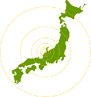
Map of Japan
Longitude: 136º22'E ~ 136º36'E
Latitude: 36º15'N ~ 36º26'N
Range: E-W 21.7 km, N-S 32.6 km
Altitude: 1 m ~1,368 m
Area: 371.13 km2
History
It was not until the beginning of the Civil War Period (Sengoku Jidai) that the name “Komatsu” appeared in historical records.
According to one legend, in the mid-Heian period the monk-emperor Kazan planted a pine sapling during a tour of the Hokuriku region. The area around it came to be known as "sono no komatsu bara" (that small-pine field with gardens). This name would eventually be shortened to “Komatsu”.
Another theory is that the city of Komatsu got its name from Komatsu Temple. Built by the Minister Taira-no-Shigemori, who was also know as “Komatsudono”, the temple stood from 1167 in the Heian period to the beginning of the turbulent Tensho period (1573-1592).
The history of the land dates as far back as the Jomon period. From excavations at the Yokaichi Chikata dig site it was found that farming had been practiced since the mid-Yayoi period. During the Heian and Kamakura periods, most of the city land consisted of marshland, so the political and cultural centers were often found in the mountainous regions of what is now present day Komatsu. These centers include Yusenji and Nakaumi among other locations.
Many local places such as Kokufu (government office of the Kaga domain), Kofu (the location of Kokubun-ji Temple), Nomi (the location of the Nomigun-ke, county hall) and Chugu Hachiin have also appeared in the historical records of the region.
The location of the current city center was cemented with the construction of Komatsu Castle in 1576 by Wakabayashi Nagato, the leader of the Echizen Ikkou Ikki religious revolt . During the civil war period, the castle changed hands frequently, and in 1639, finally end up in the hands of the third Kaga lord, Maeda Toshitsune. He would go on to govern the populace and develop the local industries, enabling the castle town to develop rapidly. Lord Toshitsune is still revered for his contributions and is known in the region as "the Restorer”.
Komatsu town came about in 1889, when the municipal system was adopted. In 1940 it amalgamated with the adjacent Ataka Town and the six nearby villages of Maki, Itazu, Shirae, Noshiro, Miyuki and Awazu to form the 176th municipal system in Japan. In 1955 the town was expanded to include the villages of Yatano, Nata, Nakaumi and part of Tsukizu, and in 1956 the villages of Kaneno, Nishio, Osugidani, Shinmaru and part of Kokufu were added to form the Komatsu City that we know today.
City Symbols
City Emblem

Komatsu City Emblem
The emblem is the stylized kanji character: “Komatsu”.
It represents harmony, peace and endless development.
City Tree: Pine
The name Komatsu (small pine) is said to have originated when Kazan Houou planted a small pine tree in the area on his travels around Hokuriku. For this reason the pine tree was chosen as the city tree.
City Flower: Plum Blossom
The plum blossom was chosen because it was the family crest of Maeda Toshitsune, the lord who retired to Komatsu Castle and built the foundations of the city.
Sister Cities & Friendship Cities
Sister cities
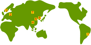
Map of Sister Cities
- Suzano, Brazil (since 1972)
City of sun, samba and flowers
- Vilvoorde, Belgium (since 1974)
Historical city with a thriving automobile industry
- Gateshead, UK (since 1991)
City known for beautiful nature, industry and art
- Jining, China (since 2008)
The birthplace of Confucianism and its many famous disciples
Friendship Cities and Other Friendly Ties
- Changnyeong, Korea (friendship cities since 1996)
Health resort area containing the Bugok Hot Spring, the largest hot spring in Korea.
Exchanges are based on common issues related to hot springs.
City homepage - Umea, Sweden (friendship cities since 2014)
The biggest city in northern Sweden, and where Komatsu Forest (a forest machine manufacturer owned by Komatsu Ltd.) is located.
While the European Capital of Culture in 2014, Umea helped promote Komatsu culture. - Angarsk, Russia (friendship cities since 2017)
A large oil field in the region, and a petrochemical complex can be found there. - Changhua, Taiwan (friendship cities since 2017)
The Chienkuo Technology University in Changhua had exchange relations with the former Komatsu College.
In recent years, they have shifted focus towards science & technology and tourism. - Guilin, China
Tourist city with beautiful mountain scenery.
Mostly hosts art-related cultural exchanges.
この記事に関するお問い合わせ先
地域振興課
〒923-8650
石川県小松市小馬出町91番地
電話番号: 0761-24-8397 ファクス:0761-23-6404
お問い合わせはこちらから
更新日:2024年09月03日